Your independent air quality reporter.
People are empowered to make informed decisions to ensure a safe and healthy environment.
The WBEA is a multi-stakeholder, consensus-based organization that leads in state-of-the-art environmental monitoring to enable informed decision-making.
We are scientifically independent.
We recognize, respect, and use traditional knowledge.
We are transparent and timely in communicating accurate and accessible data.
We are dedicated to using best available practices and technology.
We support diverse stakeholder participation to achieve consensus-based decisions.
The WBEA 2017-2021 Strategic Plan captures, in a single document, what the WBEA is about and what it seeks to achieve over the next five years. The plan focuses on four major goals:
All of the WBEA’s 38-member organizations contributed to the planning process. The development of the plan involved reflecting on past years of operation, gathering feedback and perspectives from all participants and setting goals to successfully carry the organization into the future.
The diagram below depicts how the WBEA operates and shows the relationships between the General Members Board, Governance Committee, Technical Working Groups, and the WBEA staff. The General Members Board and Governance Committee provide strategic direction and oversight for the organization. The Technical Committees determine the strategic plans and direction for each of the WBEA’s monitoring programs. The Executive Director provides operational direction for the WBEA staff, engaging science and technical advisors as required, to ensure stewardship to the overarching direction set by the General Members Board and Governance Committee.
The Environmental Monitoring and Science Division (EMSD) of Alberta Environment and Parks (AEP) is responsible for monitoring, evaluating and reporting on key air, water, land and biodiversity indicators. The division’s mandate is to provide open and transparent access to scientific data and information on the condition of Alberta’s environment, including specific indicators as well as cumulative effects, both provincially and in specific locations.
Working with a network of environmental groups such as the WBEA, as well as industry and other agencies, the Government of Alberta has been conducting environmental monitoring activities over the past 40 years under the Environment Protection and Enhancement Act.
The WBEA has entered into a contractual agreement with the EMSD. As a working partner, the WBEA is one of the agencies helping to ensure that the Monitoring, Evaluating and Reporting Program is delivered with the best expertise possible.
For more information, visit environmentalmonitoring.alberta.ca.
The WBEA is a member of the Alberta Airsheds Council (AAC), which is a partnership of Alberta’s Airsheds and provides leadership in support of healthy air quality for Albertans and the environment.
Initiated in 2006, the AAC includes membership from all ten Airsheds in Alberta and was formed to represent the collective interests of this collaborative group.
The AAC provides a forum for Airsheds to work and learn together, to continue to advance effective and efficient air monitoring, reporting and outreach, and to address regional matters.
This map shows the locations for all current monitoring stations within the WBEA monitoring network. For more information on these stations, please visit wbea.org/network-and-data/monitoring-stations.
The WBEA operated 25 ambient air monitoring stations in 2017 throughout the RMWB. These included industrial, attribution, community, background, and meteorological stations. The WBEA collects ambient air data through continuous analyzers and time-integrated samplers to ensure residents and stakeholders have the information they need to make informed environmental decisions. All WBEA air monitoring data are fully quality-assured and then sent by the end of the following month to airdata.alberta.ca, an AEP on-line database for all of Alberta’s ambient air quality data. All of the WBEA’s data can also be found on our website at wbea.org.
The Air Quality Health Index, or AQHI, is a scale designed to help people understand what air quality means to their health. It is a health protection tool that is designed to help individuals make decisions to protect their health by limiting short-term exposure to air pollution and adjusting activity levels during increased levels of air pollution.
The AQHI assists people who are sensitive to air pollution and provides them with advice on how to protect their health during air quality levels associated with low, moderate, high and very high health risks. The AQHI measures concentrations of NO2 , PM2.5 , and O3, which are three compounds that are major components of urban smog. However, it should be noted that there are other odour causing compounds measured in the WBEA network that are not considered in the AQHI. Therefore, this index gives an idea of air quality based on some pollutants, but it does not necessarily fully describe air quality in an industrial context.
The WBEA reports AQHI ratings from eight of its continuous monitoring stations in the Wood Buffalo region. The Community of Fort McKay has also developed a Fort McKay Air Quality Index (FMAQI), based upon air quality measured by the WBEA at its Bertha Ganter-Fort McKay air quality monitoring station. The FMAQI is independent of the provincial AQHI.
In 2017, the WBEA added the Janvier station to its monitoring network.
To find out more, visit: wbea.org/air/air-quality-health-index.
Low Risk 99.46%
Moderate Risk 0.47%
High Risk 0.06%
Low Risk 98.69%
Moderate Risk 1.20%
High Risk 0.11%
Low Risk 99.58%
Moderate Risk 0.38%
High Risk 0.04%
Low Risk 97.19%
Moderate Risk 2.78%
High Risk 0.04%
Low Risk 98.41%
Moderate Risk 1.50%
High Risk 0.09%
Low Risk 99.33%
Moderate Risk 0.62%
High Risk 0.05%
Low Risk 98.90%
Moderate Risk 1.05%
High Risk 0.05%
Low Risk 96.63%
Moderate Risk 2.92%
High Risk 0.36%
Very High Risk 0.18%
Low Risk 98.74%
Moderate Risk 1.16%
High Risk 0.06%
Very High Risk 0.04%
Alberta’s Ambient Air Quality Objectives (AAAQOs) were developed under the Alberta Environmental Protection and Enhancement Act (EPEA) to protect Alberta’s air quality.
AAAQOs are generally established for 1-hour, 24-hour, and annual averaging periods, depending on the characteristics of the pollutant. The graph presents a total count of ground level concentration exceedances of the AAAQOs at all WBEA ambient air monitoring stations over a five-year period, from 2013-2017. The second graph shows the exceedances for 2017 based on station locations.
When ambient concentrations of any air pollutant that the WBEA measures exceed the AAAQO, the WBEA has an Immediate Reporting Protocol that is put into action:
The table below shows the objectives for 1-hour, 24-hour, and annual averaging periods for the parameters which have established AAAQOs within the WBEA monitoring network. Where there is a dash (-) in the table below AAAQOs do not currently exist.
Parameter | 1-hour Average | 8-hour Average | 24-hour Average | Annual Average |
---|---|---|---|---|
Sulphur Dioxide (SO2) | 172 ppb | - | 48 ppb | - |
Nitrogen Dioxide (NO2) | 159 ppb | - | - | 24 ppb |
Ozone (O3) | 82 ppb | - | - | - |
Total Reduced Sulphurs (TRS) / Hydrogen Sulphide (H2S)* |
10 ppb | - | 3 ppb | - |
Particulate Matter 2.5 (PM2.5) | - | - | 30 μg/m3 | - |
Carbon Monoxide (CO) | 13 ppm | 5 ppm | - | - |
Ammonia (NH3) | 2,000 ppb | - | - | - |
*In the WBEA network TRS concentrations are reported using the H2S AAAQOs.
Note: Stations without exceedances of AAAQOs are not shown on the graph.
Air pollution transport, dispersion, transformation, and deposition are influenced by meteorological parameters, such as wind speed, wind direction, the vertical temperature structure of the atmosphere, humidity, atmospheric pressure, precipitation, and solar radiation.
These wind rose plots provided show the direction, speed, and frequency of winds at each community station in the network in 2017. The triangles show the direction the wind is coming from. The legend for the wind speeds is shown here. The percentages within each wind rose denote the frequency of the wind speed. Example: Wind in Fort McKay (Bertha Ganter) is predominantly from the north or south.
The WBEA’s ambient air quality monitoring program is conducted through both continuous and time-integrated (non-continuous) sampling methods. The following graphs provide general information for each parameter measured and the corresponding data collected for 2017. For a list of stations and the air quality parameters measured by continuous and time-integrated methods, click here.
Continuous monitoring methods measure the air quality using analyzers that are remotely monitored. In addition to air quality parameters, all stations continuously measure temperature, relative humidity, and wind speed and direction. The WBEA’s continous sampling data is available for anyone to access at wbea.org/network-and-data/historical-monitoring-data. The data for continuous monitoring methods is presented in the graphs below as the average (mean) concentrations of each parameter, along with the 99th percentile and maximum concentrations. The 99th percentile is used to show readings on the high end of the data collected at the WBEA air monitoring stations, after removing the highest 1% which may be outliers.
Note: Averages may be too small to be visible on some graphs. Hover over the graph to view specific values.
Sulphur dioxide (SO2) is mainly produced from the combustion of fossil fuels. Sulphur dioxide in the air can make breathing difficult, particularly for children, the elderly, and people with asthma. Sulphur dioxide reacts in the atmosphere to form sulphuric acid and acidic aerosols, which contribute to acid deposition and acid rain.
Time-integrated monitoring methods consist of exposing sample media to the atmosphere for a period of time, with the analysis performed by a laboratory. These sampling programs help collect additional data about the air in the RMWB, beyond what continuous analyzers can measure. The WBEA’s time-integrated sampling data is available for anyone to access at wbea.org/network-and-data/integrated-data. The data for time-integrated monitoring methods is presented below using box plots. The box shows where the majority of the sample results values fell, while the lines at either end (the whiskers) show the high and low values. The 90th percentile is used to show readings on the high-end of the data collected at the WBEA air monitoring stations, after removing the highest 10% which may be outliers.
Particulate matter consists of a mixture of solid particles and liquid droplets found in the air. Fine particulate matter (PM2.5) is 2.5µm in diameter or less, while coarse particulate matter (PM10) is 10µm in diameter or less.
In the time-integrated sampling program, particulate matter (both PM2.5 & PM10) is collected on filter for a 24-hour period, every six days. PM2.5 samples were collected at four community stations (Bertha-Ganter-Fort McKay, Patricia McInnes, Athabasca Valley, and Anzac). PM10 samples were taken at the same four community stations and three industrial stations (Fort McKay South, Horizon and Muskeg River). These filters are then sent to the lab for sample analysis to learn the chemical compositions including ionic and metal species. Ions are electrically-charged, water-soluble particles, while metals are neutral species.
The continuous analyzer can tell us the concentration of particulate matter in the air at any given time, while a sample can tell us what is making up the particulate matter in the air.
The Lower Athabasca Regional Plan (LARP) came into effect in September 2012, and was the first regional plan developed under the Alberta Land-Use Framework. More information can be found on their website at landuse.alberta.ca/RegionalPlans/LowerAthabascaRegion/Pages/default.aspx
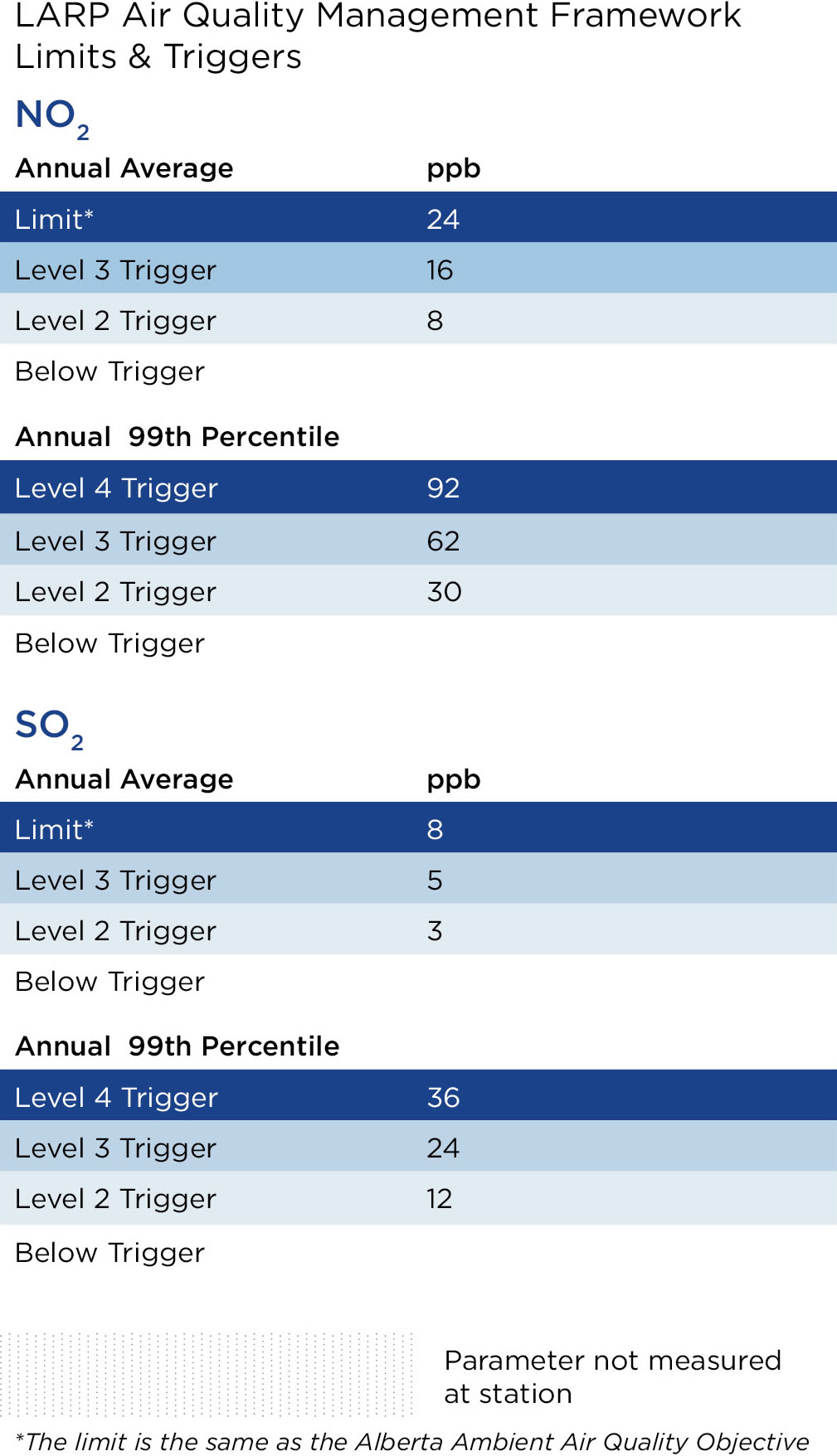
The LARP air quality objective is to manage releases from various sources so they do not collectively result in unacceptable air quality. LARP sets out limits for NO2 and SO2, as well as different trigger levels prior to the limits. When a trigger is exceeded, there will be a regional management response.
The WBEA supports LARP by conducting regional air quality monitoring and providing quality-assured data for use by AEP.
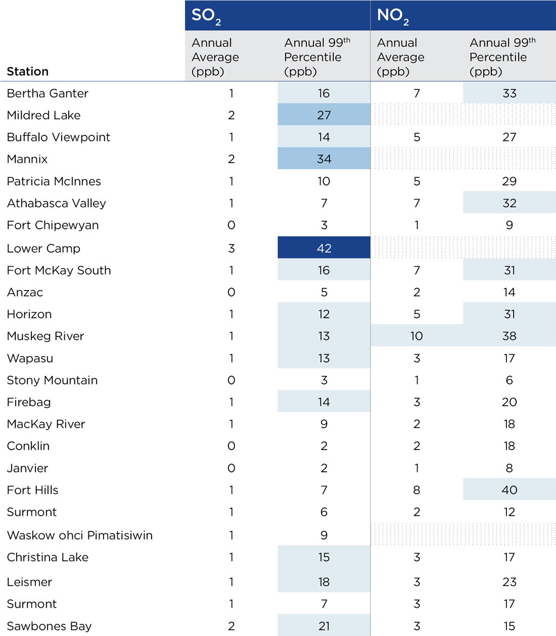
The table shows annual average and hourly 99th percentile concentrations of NO2 and SO2 at each station location and indicates which stations met the criteria for a LARP trigger in 2017 based on these averages.The use of the hourly 99th percentile data is a statistical measure to indicate upper limits of the data. Increases in the 99th percentile beyond the LARP triggers can be an early warning to help inform appropriate management actions to prevent future exceedances.
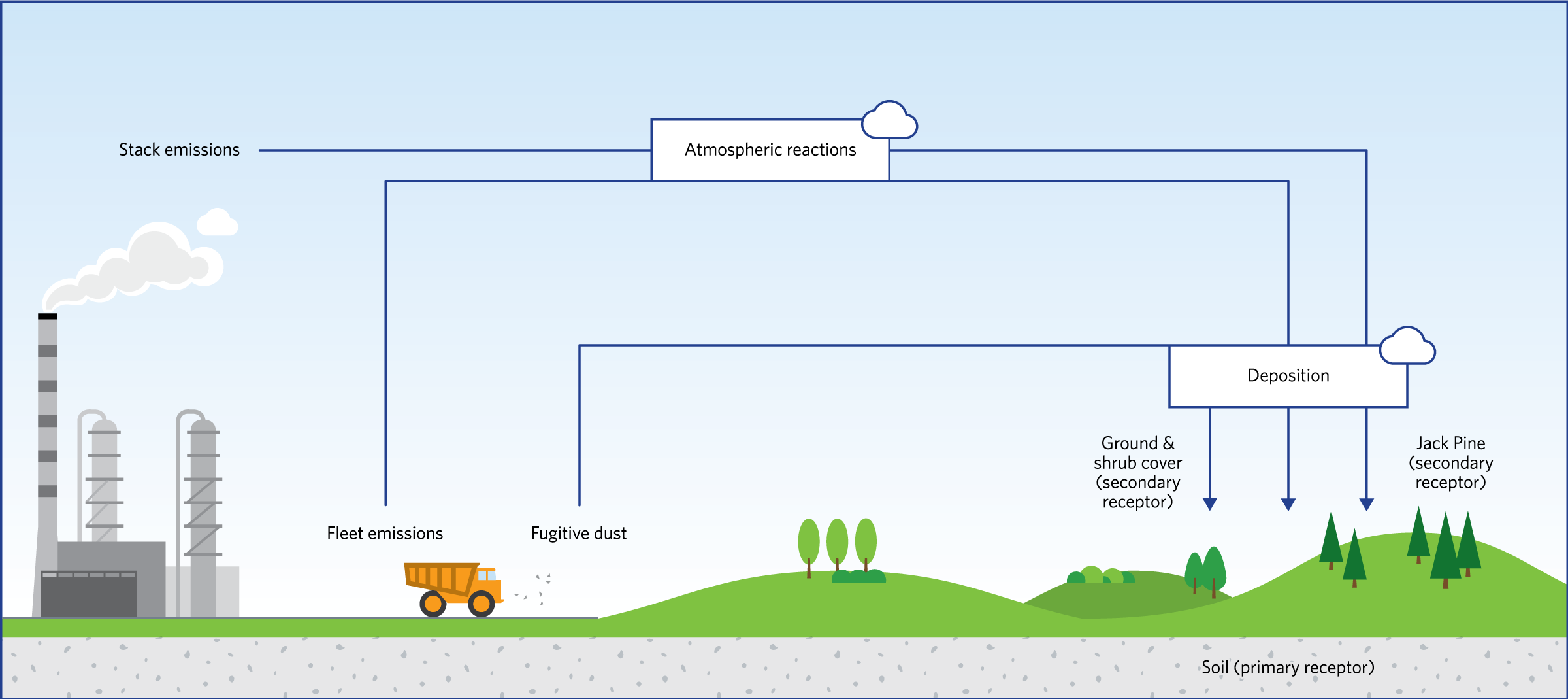
The Deposition Monitoring program, also referred to as Terrestrial Environmental Effects Monitoring (TEEM) program, was established as a mechanism to address government, community, and industry concerns about impacts to regional forests resulting from industrial development. The program’s driving question is whether emissions of acidifying compounds, like sulphur dioxide (SO2) and nitrogen oxides (NOx), have adverse effects on regional terrestrial environment. During initial program development, the upland jack pine (Pinus banksiana) ecosystem was identified as the most sensitive receptor to acidification due to their characteristically dry, nutrient poor soils with limited buffering capacity. In these ecosystems, the effects of acid deposition are expected to be observed in a cascading manner from soils (primary receptor) to vegetation (secondary receptors), first impacting individuals then the stand and onward to landscape level impacts.
The Deposition Monitoring program is the only long-term, source-to-receptor monitoring program in the Alberta Oil Sands Region that monitors stressors (industrial emissions) along the pathway (atmospheric transport) from source to the receiving environment. The integrated program allows for the determination of cause/effect relationships between air pollution and forest health. For a list of the compounds and meteorological parameters measured at deposition monitoring sites, click here.
The WBEA Forest Health Monitoring (FHM) network is comprised of 47 jack pine sites located at various distances from emissions sources. Measurement and sampling of jack pine plots occurs every six years for indicators of exposure to air emissions and deposition including: collection of soils, needles and lichens for chemical analysis; morphological measurements of jack pine trees; and vegetation community composition. Forest condition assessments are conducted annually to monitor insect and disease incidence and severity.
The following graph represents the source to sink pathway of acidifying compounds. The pathway occurs on different timescales (hourly, daily, monthly, yearly, decennially, etc.) and different environmental scales (smallest = chemical, largest = ecosystem). The further that acidifying compounds travel down the pathway, the larger the scale of environmental impact and the greater the irreversibility of that impact.
Once released into the environment, the chemical species are subject to biogeochemical reactions (largely in the atmosphere) and are deposited onto the landscape (receiving environment; i.e. jack pine ecosystems).
To better understand the nature and quantity of the compounds deposited on the regional landscape, the WBEA operates a network of air quality and deposition monitoring sites in remote locations across the Wood Buffalo region.
Various technologies are used in the network:
The WBEA’s regional meteorological network provides key data for calculating deposition rates and evaluating ecological data. The network is comprised of six paired sites: six 30-meter tall instrumented towers (“met towers”) and six instrumented tripods (“met tripods”) that provide continuous, hourly data on climatic conditions throughout the Wood Buffalo region. Each met tower is co-located with a Forest Health Monitoring (FHM) site and monitors air temperature, relative humidity, wind speed, wind direction, and solar radiation at four levels within and above the jack pine canopy, as well as temperature and volumetric water content within forest soil. Each met tripod is positioned in natural peatland clearing adjacent to a FHM site and monitors air temperature, relative humidity, wind speed, wind direction, and solar radiation. Data for all six 30-meter meterological towers can be found at wbea.org/network-and-data/historical-monitoring-data.
From the beginning, the WBEA has fostered collaborative relationships with Indigenous communities in the Wood Buffalo region. The WBEA works with local communities in developing community-led programs to investigate and monitor traditional resources. To coordinate these partnerships, the WBEA established a Traditional Knowledge Committee (TKC) to help develop and oversee long-term, traditional knowledge based, community monitoring programs. Currently, seven communities within the RMWB are members of the WBEA and participate in the TKC.
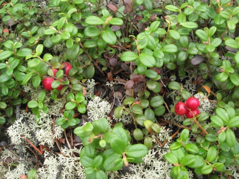
In 2010, WBEA was approached by members of the Fort McKay First Nation with concerns about observed changes in the quantity and quality of blueberries and cranberries growing on their traditional lands. In late 2010, the joint WBEA-Fort McKay Berry Focus Group was established to design a program that is directed by traditional knowledge and lived experience. It incorporates qualitative observations and western science-based tools in the monitoring and analysis of harvest locations and berries.
In 2017, the WBEA, with support from the Alberta Government EMSD, was able to offer Conklin, Fort McMurray Métis Local #1935, and Fort McMurray First Nation 468 the opportunity to develop their own community led berry contamination study.
During 2017, the WBEA worked on developing a method of collecting odour data from citizens of the RMWB to compare with ambient air monitoring being done at continuous air monitoring stations in the region. An app for use on smartphones was developed to allow for an easy to access and use tool that anyone in the region could use. The app was completed in the fall of 2017 and results are currently being collected for quarterly status reports and analysis in an annual report. The app is available on iOS and Android devices and can be found here: wbea.org/air-quality-and-odour-apps/
To increase awareness and accessibility of the program the WBEA initiated an advertising campaign comprised of radio ads and interviews, posters, and social media and tablets were installed at key locations within the WBEA Member communities for concerned citizens that did not have access to smart phones.
Based on the results of previous sampling programs, and the desire to increase the number of data points collected, the decision to purchase a semi-continuous sulphur species analyzer was approved, with initial set-up and trial operations beginning in the summer of 2018. The aim of this project is to capture and identify reduced sulphur compounds (RSCs). These sulphur-containing compounds, including H2S, carbonyl sulphide, and mercaptans have the potential to cause odours in the region. In the WBEA airshed most industrial TRS emissions are from upgraders and tailings ponds, though there is a natural background ambient air concentration of the reduced sulphur compound carbonyl sulphide of approximately 0.5 ppb.
Have you every experienced odours in our region? WBEA wants to know more about them, and we need your help.
The WBEA is researching how odours in the region relate to ambient air data, and is seeking help from all RMWB residents. It’s easy to get involved:
Download our Community Odour Monitoring Program app at wbea.org/air-quality-and-odour-apps
When you smell an odour in the air, report it through the app
The information collected is anonymous and will be used for research purposes only.
Learn more at wbea.org
Chipewyan Prairie Dene First Nation
Christina River Dene Nation Council
Conklin Resource Development Advisory Council
Fort McKay First Nation
Fort McKay Métis Local 63
Fort McMurray First Nation 468
Fort McMurray Métis Local 1935
Pembina Institute for Appropriate Development
Alberta Energy Regulator
Alberta Environment and Parks
Alberta Health Services
Alberta Health
Environment and Climate Change Canada
Health Canada
Parks Canada
Regional Municipality of Wood Buffalo
Saskatchewan Environment
Athabasca Oil Corporation
Canadian Natural Resources Limited
Cenovus Energy Inc.
Connacher Oil and Gas Ltd.
ConocoPhillips Canada
Devon Canada Corporation
Finning Canada Ltd.
Hammerstone Corporation
Husky Oil Operations Ltd.
Imperial Oil Limited
Inter Pipeline Limited
MEG Energy Corp.
Nexen Energy ULC
PetroChina Canada Ltd.
Statoil Canada Ltd.
Suncor Energy Inc.
Sunshine Oilsands Ltd.
Surmont Energy
Syncrude Canada Ltd.
Teck Resources Ltd.
Titan Tire Reclamation Corporation
Total E&P Canada Ltd.
Downloadable PDF of Annual Report
Download